The River Ant
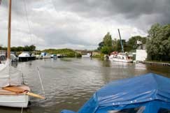
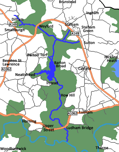
The River Ant is 17 miles long, 8.75 miles being navigable. The rivers rises east of Antingham at Antingham Pools. At Honing Bridge it enters The Broads Authority area. It turns North East around Dilham passing under Tonnage Bridge. At Wayford Bridge the river passes the Wayford Bridge Hotel and its row of house boats that line the river. The river follows quite a straight course passing Hunsett Drainage Mill, turning south and past the channel leading to the staithes at Stalham and Sutton. The river enters Barton Broad, the second largest broad. The river leaves the broad and enters a stretch at Irstead called The Shoals. All around this landscape you can see many drainage mills, Clayrack and Broadman on the east bank, and Irstead Turf Fen Drainage Mill on the west bank. The river passes How Hill nature reserve and makes a wide horseshoe bend, passing Neaves Drainage Mill as it heads towards Ludham Bridge. Finally it enters the River Bure at “Ant Mouth” close to the ruins of St. Benet’s Abbey. More...
Below is information on some of the places the river passes though:
Wayford Bridge is a village on the River Ant on the A149 road, near Stalham , within The Broads National Park. It is the most northerly point of navigation on the Norfolk Broads. However, small boats can continue to Dilham along the Dilham Canal. More...
Sutton Staithe. Below Wayford Bridge the river turns south and passes the channel leading to the staithes at Stalham and Sutton, the river banks around here are crowded with trees, marshes, and reeds, the latter harvested and used for thatching for centuries.
Barton Turf is a village on the northwestern edge of Barton Broad, the second largest broad of the Norfolk Broads. The church, situated a mile from the village, is noted for containing a very rare surviving example of a medieval rood screen across the chancel arch. Barton Turf has given its name to a traditional Corn dolly which consists of two vertical baskets to house the spirit. More...
Barton Broad is, after Hickling Broad, the second largest broad, and a nature reserve in the care of the Norfolk Wildlife Trust. It is said that Horatio Nelson learnt to sail here. Among other users are the Sailing Club of Gresham's School. Excursions on the broad can be made in the Britain's first solar powered passenger boat, the Ra, embarking at Gay’s Staithe. More...
Limekiln Dyke . The village of Neatishead is within The Norfolk Broads and to the west of Barton Broad. Access to Neatishead from the broad is by way of Limekiln Dyke, a narrow channel leading off the broad. It is famous due to the nearby RAF Neatishead radar station. More...
Irstead. The village of Irstead is situated at Irstead Shoals, on the River Ant just south of Barton Broad, the second largest of the Norfolk Broads. Several of the village's buildings are reed-thatched, including in particular the very attractive St. Michael’s Church. More...
Ludham Bridge. Ludham is a village in The Broads, at the end of a dyke leading to Womack Water and flowing into the River Thurne. 1.5 miles to the East of the village is Ludham Bridge, which crosses the River Ant which is a small boating centre in its own right. More...
The River Ant flows into the River Bure a mile below Ranworth Dyke.
Page last updated: 4 May 2022© Nigel Peacock 2022